Uncategorized

And now for something completely different!

Monterey, CA

It was raining and grey when I got up this morning so it was a great time to do some chores and planning for my next couple of weeks. Then it was off to Monterey to visit the aquarium there.

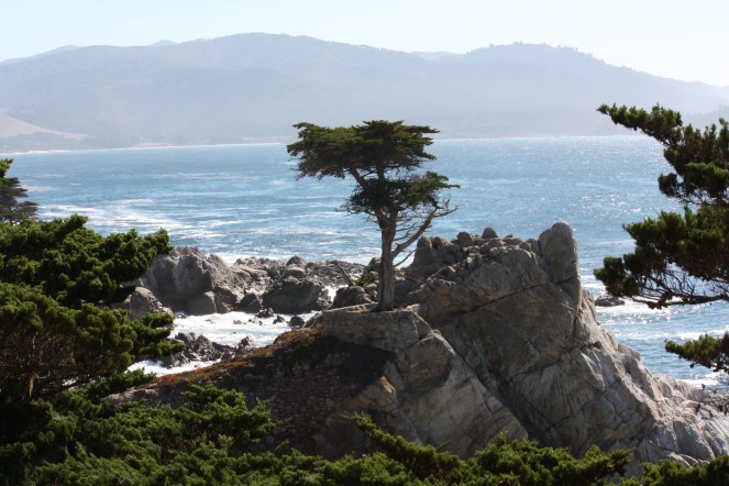
The Monterey Penisula is more developed and the traffic worse since my previous two visits. But the services and parking have improved, I think. There were a lot of expensive looking cars around, some parked with flashers on outside the shops along the main drag, a sure sign that someone who thinks they’re important was there. Speaking of important people and a sad part of Monterey’s history, John Denver died here in 1997 when his private plane crashed into Monterey Bay.

Many of the same restaurants I’d seen on last visits are still along the main street of Cannery Row near the aquarium such as Bubba Gumps, and the Sardine Factory, and there are the usual tourist shops all running along the waterfront. I had a quick soup/sandwich at Austino’s Patisserie really close to the Aquarium, having not stopped earlier for lunch and the aquarium was only open until 5pm. The Patisserie was quick and easy and hot soup hit the spot.

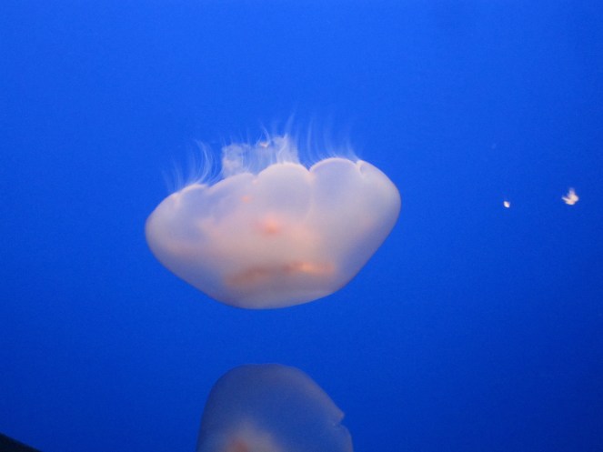
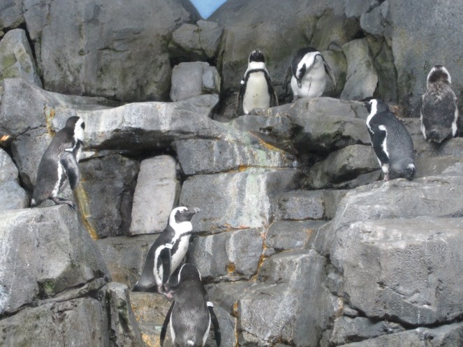
The Monterey Bay Aquarium is a little more expensive than I would have expected ($39 US vs Vancouver’s at $29 Cdn) especially since they don’t have large mammal exhibits which would presumably be more expensive to house and feed. The layout allows for rambling, rather than a linear visit, which allows you to go where your interests lead you or where there are smaller crowds. It’s a bit of a funny layout where you have to go up stairs or elevator and over to another building and down again to get to some of the exhibits. The exhibits are dynamic and there are all sorts of things that would be particularly interesting for kids such as touch pools, an ocean themed play area, and feeding times at various spots throughout the day.

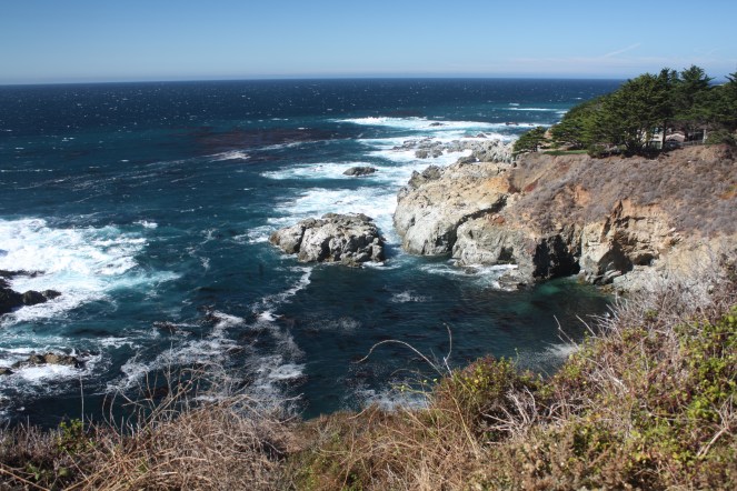
Their focus is on education, conservation and science programs and their stated mission is to insprie conservation of the oceans. Of course they have Monterey Bay right out their back door where they collect some of their species and they intake water from the bay to keep everything fresh. One of the largest underwater canyons in the world, Monterey Canyon, begins in the center of Monterey Bay so there are great opportunities to study the deep ocean there.

After wandering around the aquarium and watching some of the programming for a couple of hours, it was suddenly 5 pm and closing time. On my way out, I stopped at a grocery store, Nob Hill Foods just up the hill from the aquarium to get some things. It was a fantastic store if you’re in need of a grocery store in that neck of the woods.

All in all a nice afternoon in Monterey.

Uncategorized

Two hours to drive 17 miles

Monterey, CA

Today was brilliant sunshine, warm and calm, so although I hadn’t planned on it, I decided to do a quick run through Monterey and along 17 Mile Drive to Carmel and then down Hwy 1 to Big Sur and beyond.

What a spectacular day. I have done this trip before a couple of times, but never as the photographer and never as the driver. So it was a different experience. This road was twisty and windy and up and down and in and out, but it was fun because it wasn’t too extreme and I wasn’t hauling my trailer.

I headed down Highway 1 to Monterey, and drove through town to reaquaint myself with it and to get to the northern entrance to 17 Mile Drive – “One of the most famous scenic drives in the world”. The street actually starts in the quaint community of Pacific Grove and then you enter the Del Monte Forest and Pebble Beach’s property. I exited out the southern gate (yes, there is a charge of $10 to take the route).

My first stop was at Spanish Bay, (named for a Spanish explorer and crew who camped here in 1769), Point Joe, and The Links at Spanish Bay. Folklore is that “Joe” lived in a shack near this dangerous navigational obstacle way back when, but they’re not sure if he took the name from the point or the point took the name from him. In any case, you can see how worked up the sea is at this point.

Next stop was China Rock where Chinese fishermen built lean-tos as their homes in the late 1800s. And no coastal area would be complete without a Bird Rock, and this one has the added attraction of some seals on it as well. If other tourists hadn’t been pointing etc, I might not have noticed.

This penisula is famous for it’s golf courses, and the next one I came across was the Robert Trent Jones designed Spyglass Hill Course, which overlooks Fanshell Overlook which overlooks a beautiful white sand beach where harbour seals bear their young in the spring each year.


Cypress Point Lookout and the Lone Cypress are next on the loop. The Lone Cypress is the registered trade mark of the Pebble Beach Company. This cypress has towered over this part of the coast for over 250 years, although not without some help in the form of a support wall and stays.

The last golf course on my circuit was the most famous – Pebble Beach – but I didn’t stop in for a round. One can certainly do that if one can golf and one is willing to pay the price. I didn’t even ask.

I exited at the southern end of 17 Mile Drive which takes you out to the main drag of the cute little town of Carmel. I have loved this town since we first visited it more than 30 years ago, and bought our first piece of actual “art”. It was a watercolour of dahlias in the Carmel Mission’s garden by Carolyn Lord, a young up and coming artist then and she’s had a great career. You can see her work at carolynlord.com

After making a short stop at a cute little bakery on the main street in Carmel to get a sandwich to take on the road, I head south on Highway 1. For the next few hours I was mesmerized by spectacular scenary. I have chosen a few of the best pictures, but believe me there are many more and I could have stopped more frequently but then it just gets silly.

With leaping ahead last night, it was already pitch black by 5:30 or so which coming from Canada seems so weird when you’re somewhere warm. If it’s warm out the sun should be

Uncategorized

Have I dispelled the bridge jinx?

Watsonville, CA

Today I left Petaluma in absolutely beautiful weather for my crossing of the Golden Gate Bridge. started a bit later than usual today in the hope that the warmth from the sun would burn off any fog that is so pervasive around the bridge. And I lucked out. Either there was no fog or it had burned off, although it was starting to move back in again.

Fog, by Carl Sandburg

The fog comes on little cat feet.

Sits looking over the harbour and city
on slient haunches and then moves on.

The best viewing for the Golden Gate Bridge is from the south east, however I was coming in from the north west. I headed up into the outlook area and did the best I could with limited parking and the sun in our faces.

Then on to the Golden Gate Bridge we went (that “we” would be my trailer and I, and yes I do talk to it from time to time). I am still a little apprehensive crossing bridges, but got through it safe and sound, only to have to deal with San Francisco traffic. (if you’re wondering about the bridge story, you can read June 27th entry). It truly is one remarkable experience to go over that bridge and look down on all that’s going on around you. And yes, stay in your lane too.

My GPS took me on an “interesting” path today. I am still getting the hang of knowing when to believe it and when to trust my gut or a map. In any case I got here safe and sound and in the time that Google Maps said I would and I got to see some interesting neighbourhoods that I wouldn’t have seen otherwise.

Tonight’s campsite is ideally located just south of Santa Cruz and just north of the Monterey Penisula and within a day trip of Big Sur. This one is a “Resort” designation as well because of all the activities. And this being Halloween, were there activities!

There are goblins and princesses, and superheros and ballerinas, and that’s just the adults. Seriously, many of the adults are trick or treating to the campsites with their little goblins. Earlier there was face painting, a costume contest, rig/cabin decorating contest, and later there will be free S’mores. What a safe way to spend quality family time at Halloween. And there has been quite a lot of chatter about “shots” so I think there is some adult fun going on as well.

While I had my camera out today taking pics of the Halloween stuff, I decided to give you a taste of what a KOA looks like. As I have said before, they are the Holiday Inns of campgrounds. No surprises. Established formulas, you know what to expect. They have a great website for booking which is a bonus when you’re on the move as much as I am. They all seem to be expanding the number of cabins they have on site as well. They are small but cheap. And no, KOA is not paying me to say this.

Uncategorized

I survived part of California Highway 1

Petaluma, CA

Today I failed as a blogger and a photographer. But I survived so that makes me a great driver and proves I can put the priorities in the right place occasionally.

I have never been so challenged as a driver in my life. And I do a LOT of driving. Without hauling a trailer, the section of Hwy 101, Pacific Coast Highway (PCH) that I covered would have been challenging enough. But add towing a trailer, and it’s exhausting. The trailer handles really well but there were very few places to stop to take photos or catch my breath where the car and trailer would fit and which were flat enough.

For the first 22 miles, where Highway 1 branches off from Highway 101 at Leggett and heads west to the coast, it was two hands on the wheel, eyes totally focused on the yellow and white lines in front of me and total concentration. And those of you who know me know how difficult it is go get my total concentration.

I knew today would be challenging and long, so I got an early start (well, relatively) and I was glad that I had so that there was as little traffic as possible. The drive out to the coast was primarily through Redwood groves and there were lots of climbs and 7% grade downhills with frequent switchbacks. The road was only the width of the two lanes, with no shoulders and no guard rails. Of course, in this section, the giant redwoods would have stopped you from plummeting off the road anyway. At times the lines were literally painted on the very outside edges of the asphalt. And the asphalt was raised so not only were there no shoulders but the edges were quite a lot lower than the road surface. Thus the requirement for concentration. I think the fastest speed I go to on the road was 45 mph and 15 mph was sometimes too fast. Cruise control didn’t happen today at all.

Once out to the coast, the views were spectacular, ranging from headlands to beaches with rock croppings and “haystacks”. The road wound down the coast, following it or going over headlands, or across benches. There were infrequent small towns tucked into the coves along the coast, with the two major ones being Fort Bragg and Mendocino.

Mendocino was really interesting looking, and I took a quick drive down the main drag but I couldn’t easily find parking and I was more focused on getting on my voyage than shopping. There are lots of Victorian houses (some made into B&Bs), boutiques, restaurants, and local beers and wines to taste.

Of course, no coast would be complete without a lightouse! This one is the Point Arena Lighthouse. It sits on a high headland, and is an additional 115 feet high. It was originally constructed in 1870 but in 1906 an earthquake damaged both the lighthouse and the keepers home and they had to be reconstructed. It was lit again in 1908.

By time I reached Jenner I was running out of time, daylight and patience. I took an east-west connecting road to just north of Petaluma that took me through yet another redwood grove, through an interesting looking town called Sebastopol, and over yet more switchbacks out to Highway 101.

I arrived at the campground and was shocked when I got out to find that it was 28 degrees celsius. I set up camp and have been enjoying sitting outside at my picnic table to write this blog and enjoy my supper.

NFANA Trailer trip

California or bust

Today marks the third state for my trailer as I crossed over from Oregon to California after a fabulous run down the Oregon Pacific Coast.

I wasn’t going to travel today, but then I woke up and felt the need to get moving and so I packed up and hit the road. It was a gorgeous day weather-wise and the scenery once again was ever-changing and spectacular. I didn’t take a lot of pictures today because I was on the road for a long time today and didn’t want to stop too often and make it even longer.

First stop of the morning was sadly my last stop in Oregon. Up until this time, I wasn’t able to see very much due to the fog which didn’t burn off till 10:30 – 11 or so. I spent a few minutes walking around at the viewpoint for Arch Rock in Samuel H Boardman State Scenic Corridor. The “Corridor” is very appropriately named, and Oregon definitely went out with a bang.

Then it was on to California and continuing south on Highway 101. There was a agricultural produce check at the border, but no Welcome Centre as you cross into California so I stopped at the Redwood National and State Parks Visitor Centre in Crescent City. They helped direct me to an alternate stretch of Highway 101 that I could take to go through the Redwoods without going out of my way too much. It travels through Prairie Creek Redwoods State Park and the north entrance is at Exit 765, just south of Klamath. It joins Highway 101 just a little further south.

It is a spectacular drive through these giants of trees, towering overhead so that you need to drive with your night time lights on it’s so dark. Then the sunlight occasionally streams through warming the dew and rain on the road to cause some ground fog to create an etherial effect. (Something like Cathedral Grove on Vancouver Island for those who have been there.) I felt humbled and awed walking quietly among the towering trees through the moss and fern covered pathway to what they call the “Big Tree”. What an understatement. It’s estimated to be 1500 years old, almost 93 metres high, 6.6 metres in diameter, 20.7 metres in circumference.

Shortly after that I pulled off at an exit to a small town by the name of Trinidad in the hopes of grabbing some lunch. I was successful in doing that and thoroughly enjoyed more chowder and salad at a place on the main street called Trinidad Bay Eatery and Gallery.

And wouldn’t you know it, I wasn’t even looking and I came upon one of the 5 lighthouses along the California coast! The building itself is a small one in comparison to many of the others along the Oregon coast at only 20 feet in height, but it was built (in 1871) on the headland which makes it almost 200 feet about sea level.

After my late lunch I was back on the road and by about 4 pm stopped at a lovely campsite attached to a 9-hole golf course. It was a delight to be outside as it had warmed to 20 degrees or so during the day and I spent some quality time, cleaning up and drying out from the last campsite and getting some laundry done. Now I need to spend some quality time now, figuring out where the heck I’m going tomorrow.

Uncategorized

The beauty just keeps on coming.

The beauty just keeps on coming.
Bandon, OR

Bandon, OR


Today, I only got 106 miles! I planned it that way, though, and it allowed me to get set up at a new location further south along Highway 101 and still have the afternoon to do some exploring.

My stopping spot tonight is a small campground just south of the small town of Langlois. It’s just 15 miles or so from the tourist and fishing town of Bandon on the Coquille River. I was the only camper in the campground when I left this afternoon and they didn’t have any reservations for tonight, so the owner said I may have the whole forest to myself. They are closing at the end of the week for the season so they’re hard at work getting things tidied up for the winter.

The new part of the drive south today was mostly inland, with few opportunities to see the coast but it was pretty nonetheless. Rolling green hills and farmland, fern covered forests, and for the first time, small lakes on the east side of the highway.

Along the way, I did stop just south of Florence and drove in a bit into the Oregon Dunes National Recreation Area to see the sand dunes. The dunes stretch for 47 miles along the coast, and some of them are huge. It was foggy and drizzling at this stop. I didn’t take the time to walk in to where the dunes meet the ocean because it was quite the hike and on sand…. yup, being lazy.

I went in off the road at the south end of the park to have another look at the dunes and it had gotten brighter. Unfortunately I couldn’t get all the way in to the ocean on this road but you get an idea of what it looks like.

There were a few towns along the way today, but none were terribly inspiring except Bandon, so glad I had a chance to come back into town after setting up and having a quick lunch in Port Orford. Bandon boasts several golf courses, an Old Town, standard scenic beach, and cranberry bogs! Who knew.

On my way back to Bandon I stopped at another, you guessed it, Lighthouse. This one is situated on a plateau at Cape Blanco. It stands 256 feet above sea level, and is located on the second most western point of the continental U.S. and it’s also the oldest, having been commissioned in 1870. The waves were really rolling in all along the coast today so it was pretty spectacular. The volunteers were closing up and waiting to close the gate by the time I got there but they stayed a little late to let me take a few pictures.


Then I made my way up the Beach Loop Drive taking more pictures and walking along the various beaches until I got back to Bandon. I went out on the jetty and took some pictures of the Coquille River Lighthouse. It’s not a particularly interesting one, and as you can tell it isn’t used any longer as the harbour has been extended and there is an automated marker on the end of the jetty.

For almost the first time along the coast I actually stopped in a gift store as I wandered around town late this afternoon, but I didn’t buy anything. I’m not a very good shopper but I wanted to check out one of the local specialties. Myrtlewood is native to the Oregon coast and there are factories all along this southern portion of the coast with outlets selling pieces made from this wood. I haven’t stopped at any of them and the selection they had in the gift store I stopped at was not particularly inspiring.

For dinner I had the best table in the house at the Edgewater Restaurant (western end of 1st St. SW) overlooking the Lighthouse across the river. After participating in the obvious seafood choices for the past week, I had a craving for something else tonight and I chose a great restaurant as they did a good job of the steak dinner I chose. I’m sure they do a fine job of the seafood and the service was top notch.

I’m sitting in a coffee house, writing this blog and they have the Republican Debate on the TV. It’s quite hilarious listening to the reaction of the locals and toursits. Now it’s back to the campground now to snuggle down with Netflix for the rest of this rainy evening. I shouldn’t run into any bandwidth issues tonight.


Uncategorized

More than I’ll ever need to know about lighthouses

More than I'll ever need to know about lighthouses
Waldport, OR

Waldport, OR

Today seemed rather unproductive but was fun. I guess since I’m retired that it doesn’t matter that I have those days from time to time.

My wandering took me south along Highway 101 this morning, starting out with partial cloud as you’ll see from the pictures. A little way down the coast is the small town of Yachats, which is primarily a tourist town with cute shops and eateries. After poking around there, I continued down the coast to the Perpetua Scenic Area.


There were more beautiful wide beaches along the way, but the area gets quite rocky and rugged in the Perpetua area as you’ll see from the pictures of Cook’s Chasm and Devil’s Churn. It was relatively calm today so the surf wasn’t that impressive, but you always have a sense of how much more powerful it could be at times. In addition to Kodak moments there are a pile of paths and trails, some that are asphalt and some more rugged in the Perpetual area along with picnic areas, and campgrounds. I spent quite a lot of time hiking around the area.

Just a hint for anyone coming this way, the most popular of the State Parks (Cape Perpetual, Yaquina Head area and others) have “day use fees” which are not expensive ($5 or $7) but they add up. At this time of year they don’t have anyone there collecting them so you have to use the honour system and put the cash (or cheque! – does anyone still use those?) in a little envelope, fill out a form and put the stub on the dash of your car, which is a bit of a hassle. What I discovered today is that you can buy a vehicle passport that the Oregon Parks department sells. You can get either an annual pass for $35 or a 5-day pass for $10. Google “Oregon Pacific Coast Passport” to get more info. Makes good sense.

Just a short while down the winding road was Hecata Head Lighthouse State Park. (yes another $5 fee). The lighthouse is a bit of a walk (yes, mostly up) from the parking lot, but it is well worth the trip. The lighthouse is 56 feet high and it sits on an area at 205 feet above sea level that they dug into the headland to make it the correct height for ships to see the light 21 miles out. They have volunteers giving tours of the lighthouse, which has been restored in recent years, and I learned more today about lighthouses than I’ve ever known. I was glad to have the diversion to wait for the sun to break through the clouds to enable me to get better pictures of the lighthouse. Our volunteer was ex-navy and he told us about lighthouse, the use of the lighthouse by the navy during the second world war, and the restoration work that had been done.

One of the unique things about this lighthouse is that because they dug the building site out of the side of the headland, you can actually get above the lighthouse by taking a path up the side of the hill. (yes more climbing).

The light keeper’s house is now a popular B&B.

There hasn’t been too much construction along the way, but after leaving the Hecata Head Lighthouse area, I ran into a couple of areas where we were stopped for up to 15 minutes to be piloted through the construction. They are working on the rock barriers along the winding roads which were build in the 1930s. Unfortunately one of the areas that was inaccessible due to the construction was the area where all the iconic pictures of the Hecata lighthouse across the bay are taken.

Further along where the landscape starts to change into the sand dunes that are the prominent feature for the next 40 miles is the town of Florence, built at the mouth of the Siuslaw River. I tootled around Florence for a while and grabbed some more seafood chowder at a place literally right on the river called Mo’s which is a local small restaurant chain.

Florence was my turnaround point for the day with my intention being to visit the Sea Lion Caves just north of town on my way back to Waldport. Turns out that I was welcome to visit the cave, which I had already done years ago, for a reduced cost and a rain cheque to be used within the year, but I was told that the sea lions are not in residence at the moment! They are still out fattening up for the winter after the breeding season and won’t return to the cave until the end of November. So I headed back home for a nap before dinner.

I headed into Newport for one final look around and a casual dinner before heading back to write this blog and hit the sack.